- An article published today in the science journal ‘Scientific Reports’ confirms the ability of drones to sample waters in inaccessible areas; develop thematic maps of penguins’ roosting sites as well as thermal maps in fumaroles and 3D videos of geological structures, among other applications. All this with minimal impact on Antarctic flora and fauna and minimal risk for researchers.
- The results presented in this paper mark a turning point in Antarctic research and open the way to numerous collaborations to address important scientific challenges.
Seville, November 5, 2021.
The Andalusian Institute of Marine Sciences (ICMAN), of the Spanish Council for Scientific Research (CSIC for its acronym in Spanish), has demonstrated in a pioneering way that the use of drones -unmanned aerial vehicles- for scientific research in Antarctica allows an exceptional scientific productivity and the achievement of goals never envisaged before. This achievement is presented in an article published today in ‘Scientific Report’, a multidisciplinary science journal of the nature Publishing Group, which demonstrate the capacity for obtaining for the first time important information such as thematic maps of specific ecosystems on Deception Island.
The research in Antarctica of this institute is the result of the PiMetAn project (http://pimetan.csic.es/), which participated last February in the XXXIV Antarctic campaign at the Gabriel de Castilla Spanish Antarctic Base in Deception Island. «Given the exceptional circumstances due to Covid-19 and the lack of human resources in this project we are committed to incorporate the use of drones to address scientific questions and achieve relevant objectives. The result cannot be more favourable, which can be summarised in the acquisition for the first time on Deception Island several data sets of scientific importance «, says Antonio Tovar, principal investigator of the project. Among these results, the article documents the use of visible, multispectral and thermal sensors, and a water sampling devices to develop precise thematic ecological maps, detect anomalous thermal zones, identify and census wildlife, such as the Collado Vapor penguin colony, build 3D images of geometrically complex geological formations, and sample dissolved chemicals waters from inaccessible or protected areas.» The 10-inch multispectral camera together with visual Red Green and Blue bands obtained for the first time a map of extremely high resolution (by centimetres) where, a breeding colony of penguins and its surrounding ecosystem could be characterised including a full penguin inventory, identification of the types of mosses. guano, red algae on snow and lagoons with proliferations of green algae (Chlorophyceae) ”, emphasizes the researcher.
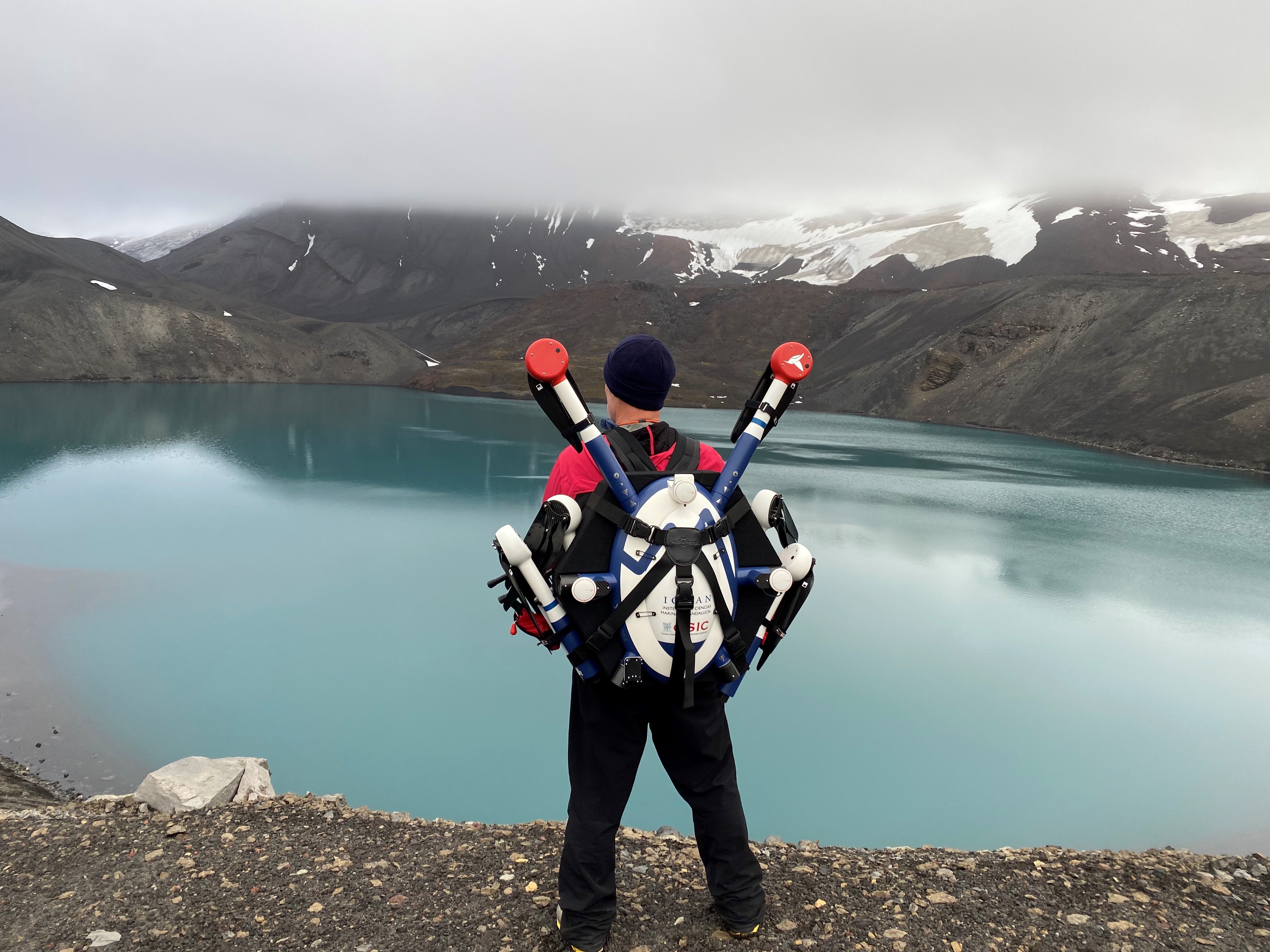
PiMetAn team member (D. Roque) transporting one of the hexacoptera drones for water sampling in Crater Lake (Deception Island).
Likewise, a 3D photogrammetry of the Murature rock formation has also been achieved thanks to the drones. «It is about obtaining the first 3D images and videos of geological formations that are uniquely useful for studying the formation of the island,» adds Tovar. In addition to this, thermal cameras have been used to detect animals and thermal anomalies (for example, fumaroles), the latter are useful for the surveillance and control of seismic activity on the island. To date, these anomalies were carried out by researchers on foot and through the use of thermal sensors installed on the ground.
Finally, an automatic water sampling system on board the drone has been used. «It is a system built ad hoc by the CSIC and the Spanish company Dronetools, exclusively for water sampling and subsequent analysis of physical, chemical and biological parameters,» emphasizes the researcher. With this system, certain chemical parameters have been sampled and analysed for the first time in a protected area such as Crater Lake and two other inaccessible areas such as the coastal areas of Collado Vapor (with strong waves and breakers) and Morro Baily (frequented by Leopard seals).
The results presented in this scientific article mark «a before and after» in Antarctic research. «These drones, not only demonstrates the usefulness of this technology in different research fields such as Biology, Chemistry or Geology, among others, but they do it in a more efficient way (it covers a greater range of action with greater precision). It is economically more effective (it requires fewer personnel and equipment), it is less intrusive to flora and fauna than studies on foot; and safer, both for flora and fauna and for researchers who enter dangerous areas to carry out their studies or to obtain samples. At the moment we are developing an automatic fauna census methodology through the use of aerial images and the application of models based on neural networks”, concludes Gabriel Navarro (Researcher of the PiMetAn team).
As a result of this work, in addition to having addressed a good part of the objectives of the PiMetAn project, a multitude of collaborations have emerged with researchers from other CSIC institutes or institutions who have been able to verify first-hand the potential of these infrastructures to address their scientific challenges . The researchers also emphasize that, in order to achieve these objectives, they have had the collaboration of the Army staff assigned to the BAE Gabriel de Castilla in the XXXIV Antarctic Campaign, as well as the staff of the Sarmiento de Gamboa Oceanographic Research Vessel and the Marine Technology Unit (UTM-CSIC).
PiMetAn, the study of the role of penguins
Our goal is to unveil the role that penguins play in the ecological functioning of Antarctica. For this, PiMetAn analyses the metal and nutrient composition of guano in different penguin colonies; studies the chemical form in which it is released to determine its nutritional and / or toxic effect; and determines the historical evolution of penguin colonies to evaluate and predict the effects that global warming has on their populations and consequently on Antarctic functioning. In order to achieve these objectives, PiMetAn has a multidisciplinary team of scientists made up of researchers in Marine and Environmental Sciences, Chemistry, Biology and Geology, and belonging to different national and foreign institutions, including the Superior Council of Scientific Research through the Institute of Marine Sciences of Andalusia (ICMAN-CSIC), the University of Cantabria (UNICAN), the University of Cádiz (UCA), the Spanish Institute of Oceanography (IEO-CSIC), Universidad Adolfo Ibáñez (Chile) , Center for Advanced Studies in Arid Zones (Chile), University of Tasmania (Australia), Edith Cowan University (Australia) and University of British Columbia (Canada).
DOI: https://doi.org/ 10.1038 / s41598-021-01228-z.
Authors reference: AntonioTovar Sánchez, Alejandro Román, David Roque Atienza and Gabriel Navarro, Institute of Marine Sciences of Andalusia (ICMAN / CSIC).
Project website: http://pimetan.csic.es/
Most of the mosaics and images obtained (including 3D maps of the BAE Gabriel de Castilla) are available to the scientific community and to society at Digital CSIC (http://dx.doi.org/10.20350/digitalCSIC/13850)
More information:
Communication and Institutional Relations Area Delegation of the CSIC Andalusia
Spanish Council for Scientific Research
Peru Pavilion Avda. María Luisa, s / n 41013 – Seville 954 23 23 49/690045854 comunicacion.andalucia@csic.es